In tonight’s class we were given a sticker for Emergency Radio Call Procedures to stick on our boat next to the radio, paired off in two’s and given a chart.
With the chart, we were asked to read all the comments and find the distance scale. Then use only the sides of the chart to get miles, distance and base. This is because latitude (lat) measures equal distance on either side from the equator. Longitude (lo) does not. The equator is 0° lat.
for example: if you draw a circle and a line in the center horizontally, that becomes the equator. Latitude lines go from east to west and measure angular distances both north and south of the equator. The North Pole is known as lat 90° N and the South Pole is lat 90° S. The halfway point between either pole and the equator is either lat 45° N or S.
Longitude (lo)
Latitude (lat)
Longitudes (aka meridians) are run from both the north and south through the earth’s poles and measure angular distances east to west of the prime meridian, which passes through Greenwich, England and is designated as 0° lo. The reason for choosing Greenwich as the prime meridian dates back to England dominating the seas when lat/los were being determined. If you go west from Greenwich one-quarter of the way around earth you are lo 90°W. If you go east instead, you are lo 90° E. Half way around earth equals 180° (east and west are same spot). This is also the approximate spot for the international date line. Both degrees of lat and lo are divided into 60 minutes and each minute is divided into 60 seconds for measurement.
When using a chart, compass and GPS system, there is another factor you need to take into account. This is known as a variation.
The magnetic North Pole is not the same as the geographic North Pole. A compass needle doesn’t point to “True” North but to the Magnetic North Pole. The difference of several hundred miles between the two is what causes the variation.
Magnetic North is either east or west of true north depending on where you are, therefore the variation is either easterly or westerly. As you go further North, the angle widens giving a larger variation. Going south decreases the variation. Therefore, when charting without a gps, you must add or subtract the variation to get your accurate lat/lo. (note: GPS systems make the corrections for you)
Next, we were given lat/los to find specific destinations. The chart we had was for Martha’s Vineyard and Block Island:
lat 41.21.19 & long 70.50.26 – you’d be off Gay Head Fl G 4 sec Gong
lat 41.26.29 & long 70.50.13 – you’d be between Pasque1 Island and Nashiwera Island
lat 41.30.50 & long 70.50.00 – you’d be at Bell Mo (A) – safe waters
National Oceanic and Atmospheric Administration (NOAA) is the organization who produces these charts for both government and commercial use.
Tidbit – lightning temperature is 3000°f
Global Positioning System (GPS) – needs 3 satellite signals to give a recreational boater their current position. There are two levels of accuracy:
one for the boaters (provides accuracy within 15 meters (49.2 ft) or less than 95% time
one for the government
A newer system is called Wide Area Augmentation System (WAAS). This has land based signals which bring errors down to 8 or 9 feet.
Tidbit: Torpedo markings on charts means stay away. If you touch one, it won’t blow up, but it will put a nice hole in your boat’s hull.
Buoys – they are all visual and there for multiple reasons. One reason is to confirm on the chart where you are, tell the coast guard if need be. But beware – you’re lookout may get bored and not be looking out for you. There is about 30 minutes in the evening before light is gone where everything loses its color and looks grey.
Numbers on buoys are white and white light means your under way. If traveling in the fog, take out your hand compass for the charts and be quiet. Listen for the sounds and count the beeps. On the chart if you see MO (A) – you’re in safe waters and you’ll see a light flashing morse code for safety.
A must have book for distance coastal boating is: Coast Pilot by Commerce.
Tidbit: Intracoastal waterway (ICW) starts in New Jersey.
Don’t go into swimming areas – you kill a child and your life is OVER!
Sounds – Signal System You’ve Gotta Know:
1 toot (.) – I intend to pass you on my port side (in the US if somebody does this and you agree – then give them 1 toot back. If not, give them 5 toots)
2 toots (..) – I intend to pass you on my starboard side
3 toots (…) – I’m going backwards
5 toots (…..) – Don’t do that – it’s dangerous
Using horns in restricted visibility –
you may hear a long blast every 2 minutes, this means power vessel is under way
two blasts every 2 minutes, means power vessel underway but not moving (this boat is not connected to the land and not making headway either)
a dash and 2 dots is a vessel under command or towing – sounds like a D
a dash and 3 dots is a vessel under command and being towed – sounds like a B
a dash and 4 dots is a pilot vessel that’s towing
2 dashes and 4 dots is a pilot vessel that’s stopped (possibly tied up to another boat)
blast horn constantly if stuck in the water
Finally, 4 toots (….) – International rule for backing up – like in Ft. Lauderdale and North River
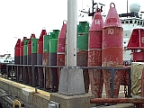
Tonight’s lesson began outside as we learned about the red and green markers in the channels (aka ATONS or Aids to Navigation System).
The red (Nun) markers have even numbers on them and should be on your Right (starboard) when coming into the channel. This is also sometimes known as Red Right Return.
The green (Can) markers have odd numbers on them and should be on your Left (port) when coming into the channel. The numbers should also be going up as you enter back into the channel. As you follow your chart, you will also see these markers clearly labeled.
The green and red striped marker (with green on top) means this is preferred channel to starboard.
A black-topped white buoy (not shown) means pass to the north or east of buoy. A red-topped white buoy (not shown) means pass to the south or west of buoy.
The last two photos here show the actual buoy tender used to put the atons into the water (or remove them) and the weight used to keep them down.
Weight for markers
Buoy Tender
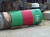
Striped Green and Red Can
Red Day Marker
Nuns and Cans
Nuns and Striped Can
The last thing we did before heading back inside was to watch a few of the boats and discussed the lights being used. Did you know that if the light up top near the captain is green, then you have the right of way to pass? But, if it’s red, don’t even think about it. They basically have the same meaning as when you drive a car.
And before I forget (2 things)
the numbering and colors on the atons mentioned above only work in countries that drive on the right side of the road. So, in countries like the UK where they drive on the left, the markers work the same way in their waters.
Nevertie your boat up to any aton
Now back to the whiteboard.
International and Inland Rules –
Rule number 1 – International Rules apply to all vessels in the oceans, rivers and bays Inland Rules apply to waters in the United States
Here’s a great neumonic for remembering who has the right of way.
Our new reels catch fish so purchase some –
Our – overtaken
New – not under command
Reels – restricted
Catch – constrained by draft
Fish – net, trawlers & the like (once done fishing you’re considered a powerboater)
So – sail (only have right of way if not any of above capacity and not under power)
Purchase – power
Some – seaplane
Depending on the situation you’re in or the work you’re doing (top 5 in list above), then you are either under sail, power or a seaplane.
LNG’s, tugs and barges all have right of way. If these vessels have to stop for any unexpected reason, they will continue moving for 1.5 miles before coming to a complete stop so stay out of their way. Also, there is a 1,000 mile rule around any USCG boats.
You’re responsible for your own wake.
Radio –
Channel (Ch) 13 is for captain-to-captain talk
Ch16 – do not chatter on this one
Ch81A is for Coast Guard only – don’t talk on this
If you’re coming to a bridge that needs to be opened, hail 13 – call the bridge person “Captain” then offer them some cookies, etc. (bribery works), otherwise you’ll be sitting for a bit.
Overnights – you should have 2 anchors, signaling devices, radio, flares, flags, etc.
Do not risk your lives for anybody or anything!
Man overboard/pre-trip checks
if a person is in the water the first thing you need to do is yell man overboard port or starboard. If you’re on a powerboat, this helps the captain know to turn the opposite screw.
Next, keeping your eye on this person use your full hand to point in the right direction (not your finger).
Then, throw a type IV PFD (personal flotation device) out to them (usually a ring or square cushion)
What to tell your guests when you go out on your boat.
– how the toilet works if you have one on board
– where the fire extinguishers are and how to use them
– where the life jackets are and have them fit one to their body (make sure they’re out of the cellophane)
– where the throw ring is
– show them the chart
– show them how to take the helm
All these things help you look confident, show your guests that you know what you’re doing, which in turn makes your guests feel comfortable being on the boat with you. G-d forbid something happens to you, your guests need to know how to take over.
Departing and returning to a dock –
If you’re in a power boat, you’ll find half the time it’s best to leave the dock with the stern. To do this, put the fender close to the bow, push on it, then backup. If you have someone on board with you, have them position the fender alongside the bow so you can back up.
Conversely, it’s better to back in.
Anchoring –
It’s best to have 2 anchors on your boat, especially if you’re going to do overnights. You’ll also need a chain on each anchor. The chain’s purpose is to allow your line to have scope (shock absorber). The length depends on the deepest water that you plan to be in then times 7 (aka scope of 7:1). So if you will be staying in 20-ft. water, you’ll need an anchor that’s 140-ft.
Before you drop anchor, you’ll need to check the bottom and its depth. If you can’t see the bottom, make sure you check it on your chart. Then check to make sure the rode is scurely tied to the boat, but not to the side or only the stern of your boat. Once you drop anchor, back up to let the rode out, then come back in half way. This gives you a more secure (taut) line and keeps you from drifting too much. Also, note what’s around you (church, restaurant, etc). This will help guide you. If your surroundings change, then you have a problem with your anchoring.
Towing a Skier –
You, as the captain, always need to be watching in front and back.
Adverse Weather –
Winds coming in from the Northwest are highs, from Southwest are storms (at least here in New England).
High pressure – the air goes outward, low pressure – the air goes inward. A front is in between a high and low.
Cold air comes under warm air. It condenses moisture, then causes thunderstorms. So watch the clouds.
Little wisps are start of arriving fronts. They also look like fingers of ice and are known as the cirrus clouds.
Stratta clouds are flat clouds that go across the sky.
Clouds that clump or look like balls are either rain or snow.
A seabreeze rises 35k feet and clouds look like an anvil. It sucks wind from every direction. Then the friction causes thunder and lightning, which in turns gives the sheets of rain.
When this happens, make sure everybody on your boat puts on their life jackets, gets below (if possible). The one thing you don’t want to do is get cold and goopy wet. If you’re wearing glasses, take them off (you can’t see with them anyways). On a sailboat? Heave-to.
If a hurricane is approaching and you can’t stop, then go around (peel off) and get yourself to the 8PM marker.
In Boston? Ch3 has weather forecast. Cape Cod? Ch2. Everywhere else – www.sailcast.com
That’s it! we’ve covered a lot here. Any questions, just ask and I’ll do my best to get you an answer. Homework is read chapter 6 & 7.
Well, now you can. Marineland in St. Augustine, FL. offers 5 programs for you to choose from:
– Touch & Feed (ages 3 and up @ $26pp) – you get to literally touch the dolphins and feed them fish, hold their tails, splash them and they’ll splash you back
– Dolphin Designs (ages 5 & up @ $85pp) – you get to do have artclass with a dolphin. Here you’ll pick up to three colors for the dolphin to paint on a canvas that you hold over the water. Once the dolphin is finished painting you two can spend a few minutes interacting.
– Discover Dolphins (ages 5 & up @ $149pp) – here you’ll get to go into the shallow-end of the pool with the dolphin for twenty minutes. Anyone under 8 must be accompanied by someone 13 or older and also participating in the Discover Dolphins program.
– The Immersion (ages 5 & up @ $189pp) – here you’ll not only get to spend time in the shallow water with the dolphins but also swim with them in the deep end for thirty minutes. You’ll wear a snorkel mask and life vest. Anyone under 10 must be accompanied by someone 16 or older and also participating in The Immersion program.
– The Quest (ages 13 & up @ $330pp) – here you get to enjoy being a member of the crew and play with the dolphins just like the trainers do. You also get to paint with the dolphins and receive a custom-designed beach towel. Only four guests allowed at a time in two groups of two.
If you don’t want to participate in one of these programs you can just sit back and watch the dolphins swimming around with footballs in their mouth, playing with hoola hoops, jumping in the air or interacting with others. Dolphins recognize blues & greens, so if you’re wearing one of these colors and stand in the window of the large tank – they’ll stop by and say hi to you. Occasionally they’ll even throw the football over for you to catch and throw back.
Marineland is on Rte A1A between the European Village in PalmCoast and St. Augustine proper with the ocean behind it. Park is open 8:30am to 4:30pm everyday. For more information and/or reservations go to: marineland.net or call 1-888-279-9194. Be sure to say hello to Marc and Simon (the guys at the end of the video).
Tonight’s class was all about safety equipment, life jackets and fire extinguishers.
Did you know boaters have just 40 seconds to either getting the heck off the boat or grabbing your fire extinguisher once a fire starts? But, make sure it’s the right type of fire extinguisher (Class B) AND it still works.
According to the USCG rules, you must have the following on your boat:
(depending on the size of your boat and the type of fire extinguisher)
Boat Size
# USCG Type B
< 26 ft.
1 B-1
26 ft. to 39 ft.
2 B-1s or 1 B-2
40 ft. to 65 ft.
3 B-1s or 1 B-1 & 1 B-2
Type Fire extinguisher
USCG Type B-1
USCG Type B-2
Underwriters Laboratories Listing
5B
10B
Aqueous Foam (gals)
1.25
2.5
Carbon dioxide (lbs)
4
15
Dry Chemical (lbs)*
2
10
Fe-241 (lbs)
5
10
* most popular type of fire extinguisher on recreational boats
However, an electrical fire needs a CO2 fire extinguisher and a grease fire uses dry chemical.
Life jackets –
Type 1 is good for offshore, sailing and must be on all commercial vessels. These will turn an unconscious person overboard right side up to keep their head out of the water, great for rough waters and they provide 22 lbs of flotation which means it displaces 22 lbs of water when overboard.
Type 2 are similar to type 1 except they are considered for near-shore, has less buoyancy and not as comfortable.
Type 3 are known as flotation vests, similar to type 2 but will not turn an unconscious person upright. Not good in a delayed rescue.
Type 4 are known as throwable devices and used for those who have fallen into the water.
Type 5 are known as special use devices and must be used according to its label.
All Coast Guard approved lifejackets must show the manufacturer’s name and approval number. You are required to have at least one lifejacket of suitable size for each person on your boat.
Other Safety Equipment to have on board:
– Bell – if your boat is over 26 ft, MA law requires one
– Strobe Lights – can only be used in Inlet Waters, Not Intl’ waters
– Flares – minimum of 3 on a boat
– Ditch bag – good for keeping things in that you would need if going overboard or if you’re going into a dinghy
– Anchor line – long enough for the deepest waters that you’ll be in times seven
– Ladder – again, required by MA law
A good book to have is: Chart No 1
Homeland Security – 1- 877 – 24 – watch
homework assignment – Chapter 5. No class May 25th – Memorial Day. See you in June!
I just started taking a boat safety class tonight, and it’s being held at the Coast Guard office in Boston. There’s about a dozen men and women in the course with a good mixture of powerboaters and sailboaters. Some of us (like me) don’t have our own boat, but it’s good to know this stuff anyways.
For the first night we got an overview of what to expect and lots of stories. This is how the teacher prefers to teach rather than read right out of the manual. For the book we’re using the Thirteenth Edition of Boating Skills and Seamanship by United States Coast Guard Auxiliary.
Some safety tips given tonight:
– Don’t swim if you fall in the water, no matter how good a swimmer you are. If you see something floating (like the boat) stick with it. You’ll be saved a lot faster and you won’t be as tired.
– If traveling a lot you’ll need a chart kit and marine guide book.
– When using a compass, put it down away from your radio
– When going out with the boat, make sure you file a float plan and/or let someone know you’re going out. Then call them when you get back.
– While on the boat with others, make sure your guests know where your compass, flashlights, life jackets, etc are and how to use the bathroom (if you have on board).
– Fishing boats need to get out of everybody’s way except a seaplane.
– Always know where you’re at.
– Don’t allow children to sit on the bow. Too many have gone overboard and drowned.
Did you know that the Coast Guard can now do drug and alcohol screens right on the water? And when a middle aged man is found overboard he is either drunk and/or unzipped?
If you have the book and want to follow along – homework is chapters 1 – 4. Yikes!